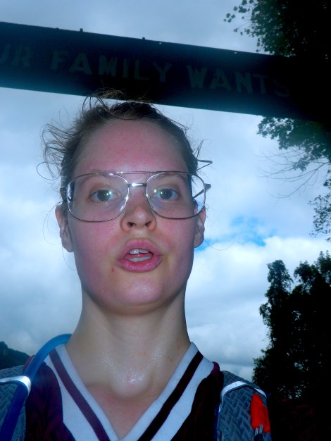
A low fog blankets the dirt road, concealing the cabins and tents. It is midnight in West Virginia and I am in a fairy tale. Or possibly a horror story. West Virginia is green and overgrown. Fog covers everything and refuses to back down from the sun, even at midday. There is a nostalgic mystery in West Virginia; the stuff of childhood fears and ill-advised adventures.
I am here with my family because my sister wants to go white water rafting at New River Gorge before she leaves for six months to Antarctica. I have never been white water rafting before and the thought of getting splashed for five hours with cold water didn’t seem too appealing to me so my mother and I decided to go on some hikes instead.
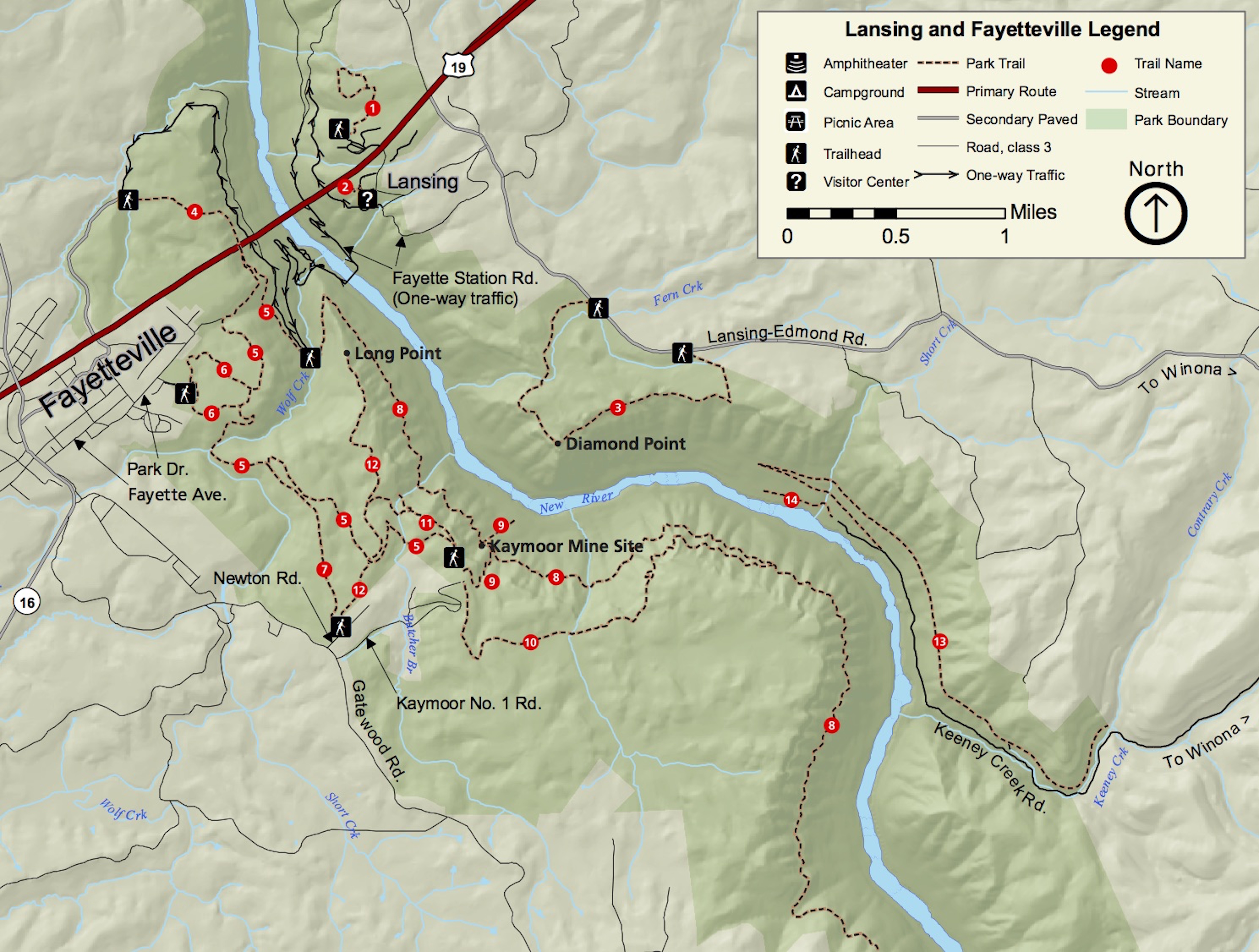
All the hikes and scenic drives we did can be found on this map from nps.gov
We stayed in a luxury rustic cabin at Adventures on the Gorge. I say rustic because the only thing inside were beds and those gym mat-type mattresses. I say luxury because it was also air conditioned. It was nice and not that expensive when you consider four people were staying there. We cooked our meals on the tiny front porch with our camp stove and ate on the floor because we forgot to bring chairs.
My sister and dad left early the next morning, my sister with the message to have fun, my father with the task of keeping her alive. My mom worries. My mom had also found what was considered the best hike in the National Parks system according to a 2015 USA Today contest. We thought we should wait for my dad and sister to do that hike, considering it was the best, and so set off to find the visitor’s center for the New River Gorge and get their opinion on what we should do instead.
The visitor’s center has a museum with some history but nothing that requires a special stop; every hike is peppered with several plaques that have more detailed and specific information. We got a free map and talked to Chris, a very tall and surprisingly overweight Ranger. We told him what we wanted to do and he suggested the Long Point hike because you can see the arch bridge. Well, we saw the arch bridge already. We even drove over it a few times. We wanted something new.
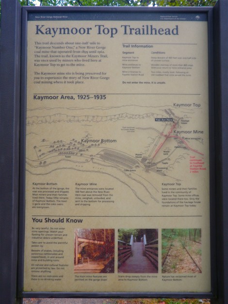
I asked about mines and he reluctantly told us about the Kaymoor Mine hike. It is considered strenuous by the brochure and features 821 steps down . . . and then up if you don’t want to die down there. He told us we didn’t have to do the steps because they were at the end. Most people look at me and my mom and assume we can’t do things. We went rock climbing in Utah once and the guide didn’t want to take us. Well we were awesome and people should stop judging us.
Following the map from Ranger Chris, we ended up driving through Fayetteville, possibly the cutest town ever to exist but I’m not sure. It was full of tourist trap shops but also every day stores and businesses like law firms and insurance companies. There were a lot of restaurants but not a lot of vegan or vegetarian or gluten-free food. I did see a hipster sitting outside something called the Cathedral Café, a café inside an old church, complete with stained glass windows and a turret. There weren’t any signs for the Kaymoor Mine hike until the trailhead but it was easy to find and there was a little parking lot.
Kaymoor Miners Trail
So much to explore.
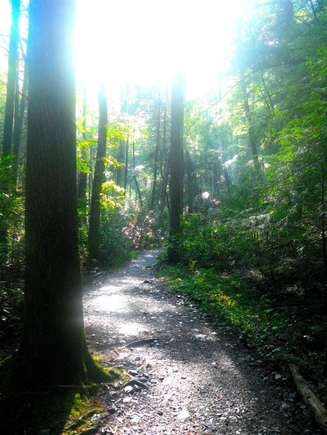
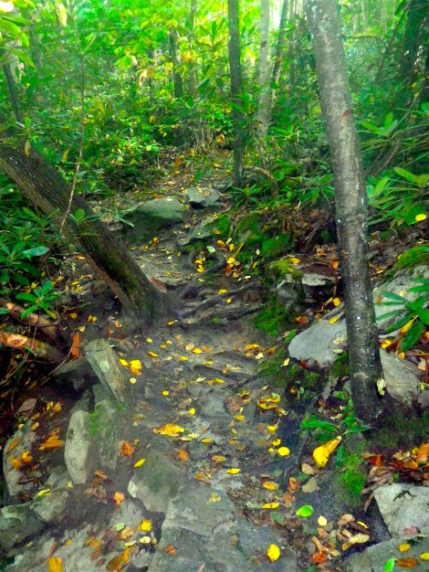
A little plaque greeted us about the history of mining in West Virginia. Then we were in the Florida jungle. Tropical plants loomed over our heads between skinny trees that looked like they had been stretched into the sky. The thick air fogged our glasses, making the treacherous terrain even more dangerous. Sweat (or was it dew?) plastered our clothing to our slick skin. Moss grew so large they were no longer the spongy patches of Michigan, but looked like a blanket of tiny ferns. West Virginia is humid.
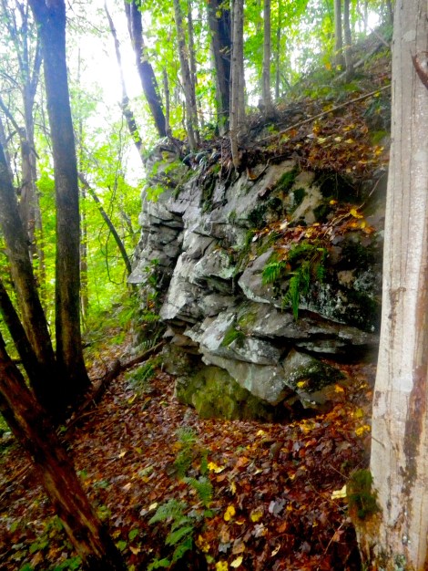
The rocky terrain required us to keep our eyes on our feet. Roots also posed a problem; they were like those banana peels in cartoons. All this looking at our feet made us miss some gorgeous scenery; we had to completely stop moving if we wanted to look up. When we did, we were surprised at how far down into the canyon we had come. Plants and trees clung to the sides of the rocky cliffs overhead. The trees up ahead blocked the view of the gorge but we could hear the water below.
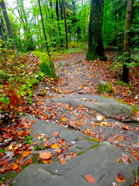


The terrain was rocky.
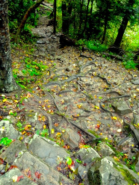
Don’t be fooled by these roots; they are slippery.
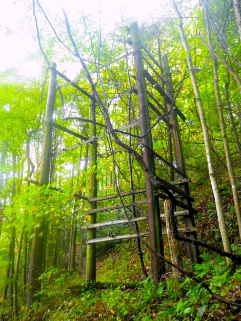
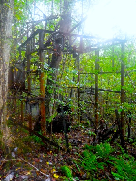
The abandoned mine structures blend in with the forest.
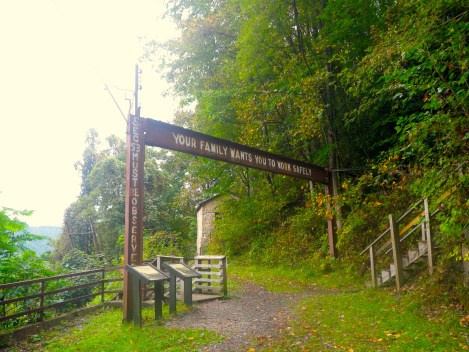
We took a short stairway and finally landed at the abandoned mine site. As I soon learned, it wasn’t the actual mine site but the place the men gathered before they were taken down. Refurbished signs extolling the importance of safety sat in front of a few abandoned buildings, some too dangerous for explorers and kept behind a barbed-wired fence.


Scrap metal littered the path.


This isn’t a tree; it’s a pole with vines on top.
A trail to the left and to the right drew our attention but then we realized it was actually the Kaymoor Trail, an 8 mile trail that cuts through the top of the Kaymoor mine site. After puttering around for a few minutes we decided to do the steps. All 821 of them.
The steps were slick and made up of two boards with a tiny gap between them. After a while they started to play tricks on me. My eyes kept confusing the tiny gap between the two boards with the space between each step. It was hypnotic and I had to stop every 50 steps or so just to realign my brain.

The top of the steps to Hell.

Deceptively innocent looking.
The air around us became darker as we plunged into the gorge. It was silent. All the birds were well above us and the only sound was the occasional tree branch cracking off and plummeting to the leaf-strewn floor below. There was a sense of desperation and rawness about the place. Abandoned mining equipment littered the ground and stood amongst the trees as if trying to blend in.

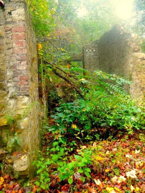
A warning sign greeted us at the bottom. I decided to leave the trail anyway but my mother stayed behind. I forged on ahead and saw buildings that had had their foundations ripped out by the government for being too unstable. The buildings were just dropped onto the forest floor where they slowly sink. Barbed wire lined their perimeter. Electrical houses had become rusted skeletons; a literal outline of the buildings. Jagged metal starting to get buried sprouted up out of the ground like perverse daisies.
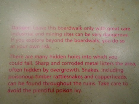
A fairly alarming warning sign.

You get the sense you’re not supposed to be here.
Enter a caption

The tops of the buildings are almost eye level, they’ve sunk so low into the ground.

Not only is the mine abandoned, the trail looks abandoned as well.
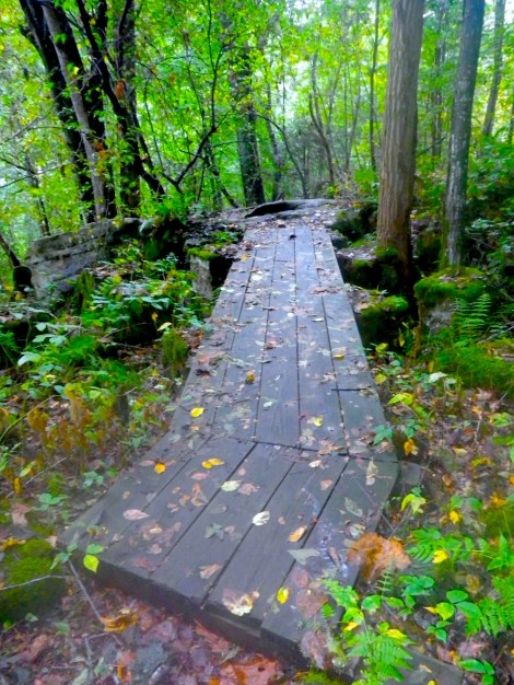
We were late. We had the car and we had to pick up my dad and sister from rafting. I wanted to explore but my mom wanted to leave. I have never been afraid on hikes before but this place was eerie. It felt wrong. I asked for ten minutes to explore and I plowed ahead with my heart in my throat. The trail threatened me with rusty metal, unstable footing, and holes. Then, inexplicably, there was a pristine wooden footpath over a particularly rough patch of ground.
My mom would yell out every so often to make sure I wasn’t dead but her voice was getting further and further away. I wanted to see the river but I couldn’t hear it anymore over the sound of my pounding heart. It was silent otherwise. And then, I heard it: a quick rattle.
There are snakes in West Virginia: the rattlesnake and the cottonmouth. According to the woman who checked us in at the cabins, cottonmouths smell like rotten cucumbers. This has led me to sniffing the air like a dog whenever I am walking around. I’m not sure if she was joking or not because if so, it’s pretty good. Still, I’m not going to take any chances.
So when I heard the rattle, I immediately stopped. “Hello?” I called, but I’m not exactly sure why. Nothing. I decided to turn around. We were late, it was no fun exploring on my own, and I really didn’t want to get bit by a snake. Apparently the coke ovens that should have been up ahead were prime snake territory. I didn’t need that in my life.
I turned around and took off running. I jumped over a hole when I heard it again: the quick rattle. I whipped around. The snake was chasing me! No, wait, that’s not right. But when I turned, I heard it behind me. I whipped around again. The path was empty. Then relief flooded me, over taking any embarrassment. The rattle I heard was my chapstick and flashlight clinking together on the back of my Camelback.
I started laughing the laugh of those who have had a near death experience. My mom just heard hysterical laughter coming from the depths of the woods her daughter had disappeared and was understandably concerned and so yelled to make sure I was okay. I told her the story as we climbed back up the 821 steps and I know she would have laughed if we weren’t trying to climb steps in 10,000 degree humidity.
A strangely nice bridge.

Almost tripped and died on this pipe.
The climb up was hard. We couldn’t breathe. Our lungs were slowly filling with water just as the rest of the water was sweated out of our bodies. Our slow pace did allow us to see all the things we had missed on the way down because we were too busy looking at our feet.

The steps were built on top of the old railroad.

This structure is about 25 feet high and we didn’t see it on the way down.

Caterpillars crawled on the railings. I named this guy Bert.
We were dead by the time we climbed up but were so happy to reach the top. Then, of course, we had to climb up the rocky terrain we had forgotten about in our stair agony. We were definitely going to be late picking up my dad and sister. We decided to try and book it even though we could both use a rest. I was pretty sure my lungs were at pneumonia-fluid level but we trudged on.
We reached the top and I just knew we were going to get bit by a cottonmouth because I was breathing through my mouth by that point and couldn’t smell. We did see a few people on their way down as we were coming up. If I was on my way down and had never been, I would probably reconsider if I saw us coming back up.
So…sweaty…
We picked up my dad and sister. My sister had fallen in. According to her, she got pushed in. Either way, she got a West Virginia nose flush.
Endless Wall Hike
My dad wanted to go on the “Best Hike” but said if the wall wasn’t endless, he was going to sue someone. My sister wanted to take a nap. Understandable.
For something with the label of “Best Hike,” it was surprisingly difficult to find. There is no sign except for a tiny, tiny wooden brown sign low to the ground that says Fern Creek that leads to a parking lot. We drove past it. We turned around at another parking lot a little ways further that marks the end of the hike. We were told most people will go to Diamond Point, the halfway point, and turn back because they don’t want to have to walk back to their car on the twisty West Virginian roads.
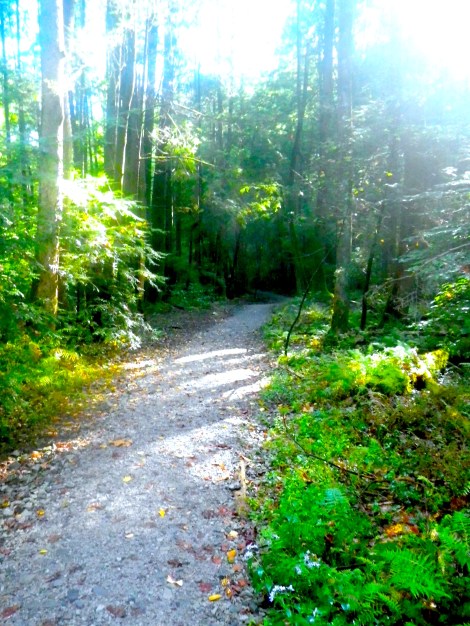
The trailhead was easy to find and soon we entered the rip in space/time and were in the Florida jungle again. The trail was easy going at first but got rocky the further we hiked.
Beginning of the trail was an easy walk.

The trees stretched high into the sky.

Tropical plants in the middle of West Virginia.
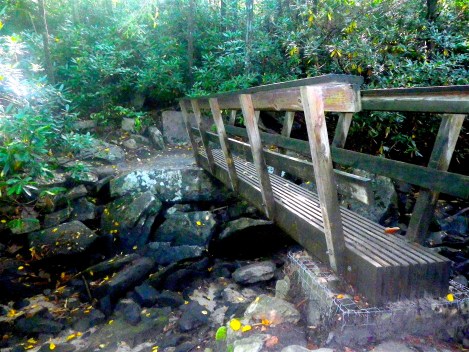
The bridge over Fern Creek.


The trail got rockier the further along we went.
The article mentioned ladders to get down into the valley. Ranger Chris told us the ladders were for rock climbers. We were climbing on rocks so we considered ourselves rock climbers. They were hard to find. We passed a wooden sign that pointed to Climbing Access straight ahead and Overlook a little to the right. We went to the Overlook first and saw the New River Gorge. It was pretty cool but not what I would think of when I thought “best hike.” We did see some climbers rappelling down into the valley fifty feet or so below and we started to notice all of the anchor bolts pounded into the rock.
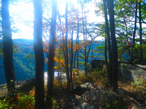
The Overlook. Not Diamond Point.

You can just see the rock climber on the left side of the picture.

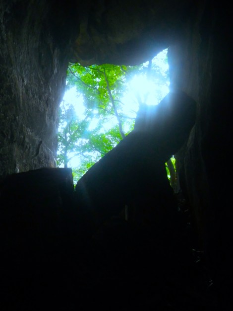
We weren’t sure if the Overlook was Diamond Point so we went to look for the ladders before it got dark. The ladders were well hidden. The best way to get to them is to go back to the Climbing Access sign, walk towards the edge of the cliff and go RIGHT. Keep going RIGHT. You’ll go around a bend and there is the first ladder. It is metal, painted black, and it is pounded into the rock so there is little chance of it moving unless something horrible happens.
The first ladder is a little tricky to get to and you have to either go under a low railing or reach your leg over an abyss. I went under the railing. The ladder is short and puts you inside a cave formed by mammoth rocks. Another ladder takes you further through the rock cave, and the last puts you on the valley floor where there are more rock-formed caves to explore. It reminded me of Utah once I was inside the caves and couldn’t see all the green. There were some beautiful views and some fun climbs but Utah is known for its rocks for a reason. If you want a Utah-lite experience then this hike and the ladders are for you. We eventually got bored (something that would never happen in Utah) and went back up the ladders to figure out this Diamond Point thing.

The ladder peaking out from the cave.

We decided to keep going. We weren’t tired and didn’t think we had gone a mile yet. And if we reached the end, we would just walk back to our car. I’m glad we went forward. Diamond Point is NOT the Overlook. Diamond Point is the reason this is considered the “Best Hike.”
Diamond Point is beautiful. We had been seeing the gorge constantly but now the river was on full display. Despite it being so far away, the river is loud and so it’s not just a visual experience. The Grand Canyon was beautiful but all I could hear were other people or wind. Diamond Point lets you hear the river, the leaves rustling, and birds talking.
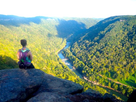
Diamond Point.

Fayette Station Drive
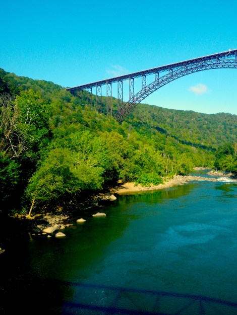
The New River Gorge Arch Bridge is only 40 years old. Before then, it took about 45 minutes to go from one side of the gorge to the other, driving on a twisting road until you reached a shorter bridge closer to the river.

The New River Gorge Arch Bridge from below.
We started on the north side and got on Lansing-Edmond Rd. Take a RIGHT on Fayette Station Rd or WV-82. Go LEFT at the fork and then just follow the road. It will eventually become one-way as you go into the gorge.
Just staring out the window as we drove past was worth it. There were a couple of turn-offs for photo opportunities of the arch bridge. We crossed a working railroad track and reached the older, shorter bridge. We parked and white smoke started pouring out of our car. Not mechanically inclined, I went onto the bridge to take photos. They would figure it out.
There are a few plaques detailing the history of when the two towns became one. They also say the foundation of the old general store is still there, but either I couldn’t find it or I didn’t know I was looking at it.

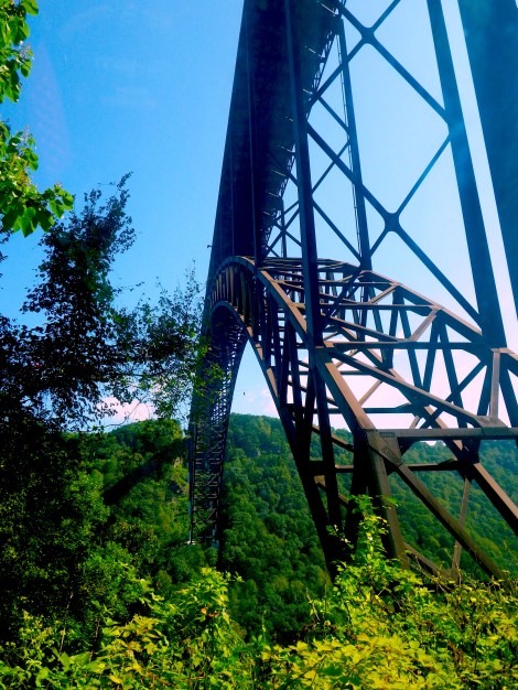
From the lower bridge, looking southeast.
From the lower bridge, looking northwest at the Arch bridge. White crane on the bridge for scale.

They were taking awhile with the car. I went back and found out my sister had ridden the brakes until they were so hot they started smoking. My dad had taking off the hub cap and exposed it to the air. It took forty minutes for them to cool down enough to start driving again. Side note: DOWNSHIFT when you go down and don’t ride the brakes.
The way back up was gorgeous. Rivulets of water trickled down the rock walls next to the one-lane road. I wanted to get out and explore the whole area but there was no place to park. We watched the world go by through our windshield and it was good.
Right off the side of the road.
The New River Gorge Arch Bridge.

Loved reading this thaank you
LikeLike